Sorry for the lack of posts today, kids have kept me very busy.
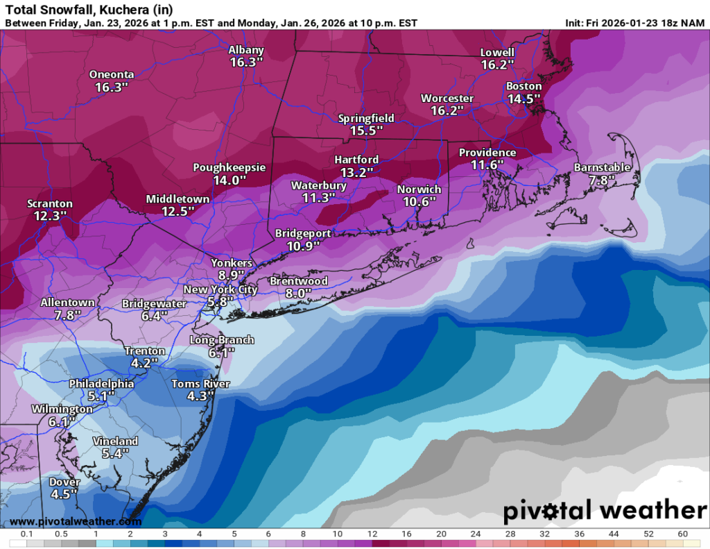
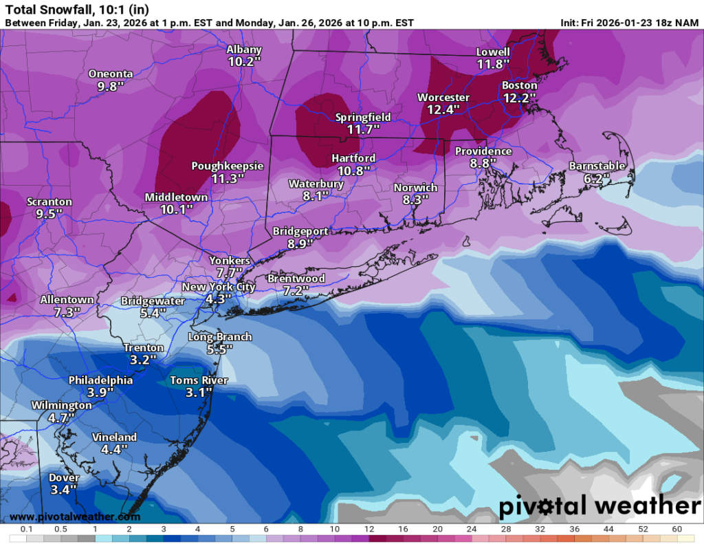
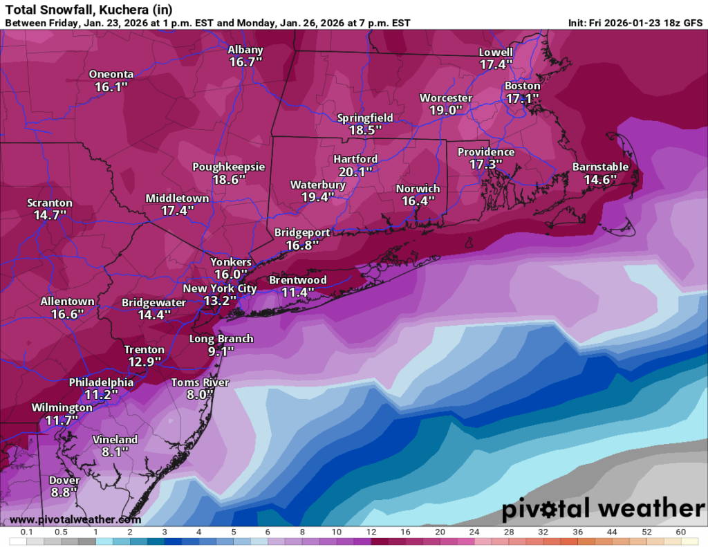
My overall thinking on the storm remains the same. Expect 6-10” of snow area wide. For LI and city snow is likely to change over to sleet around 6-8PM and it will sleet for several hours at least. Sleet accumulation may be as much as 2-3” which will make shoveling very difficult. There may be some additional snow at the end of the storm as well before sunrise Monday.
After the storm the coldest air of the winter will filter in to the region. Lows may go below zero with highs in single digits to low teens.
Here’s the latest update on the storm that will impact our region on Sunday:
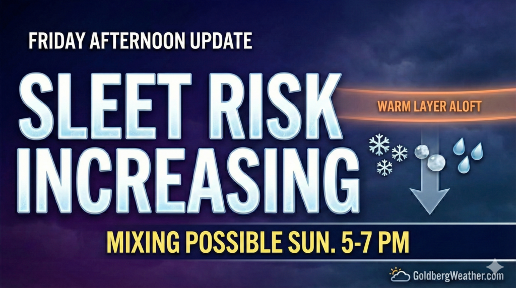
This afternoon’s model runs are starting to hint at a warm layer aloft, which would mean sleet mixing in later Sunday. The problem is the models still don’t agree on how soon that happens or how much sleet we actually see.
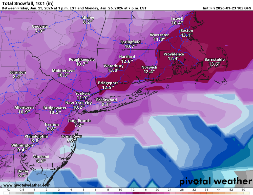
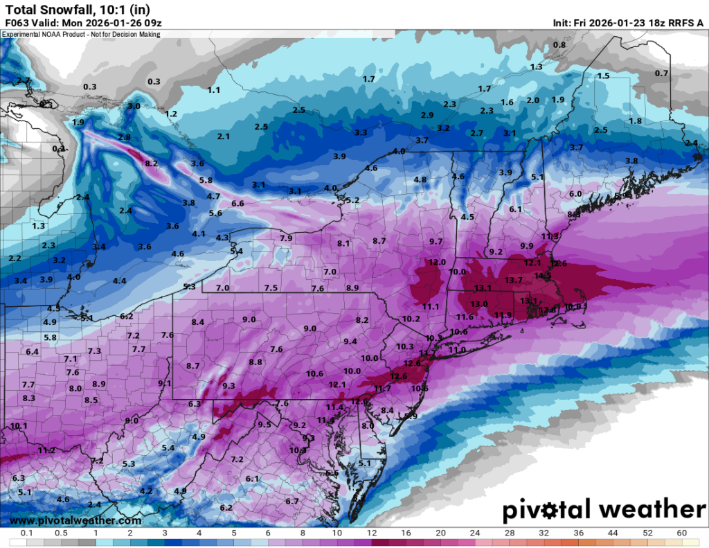
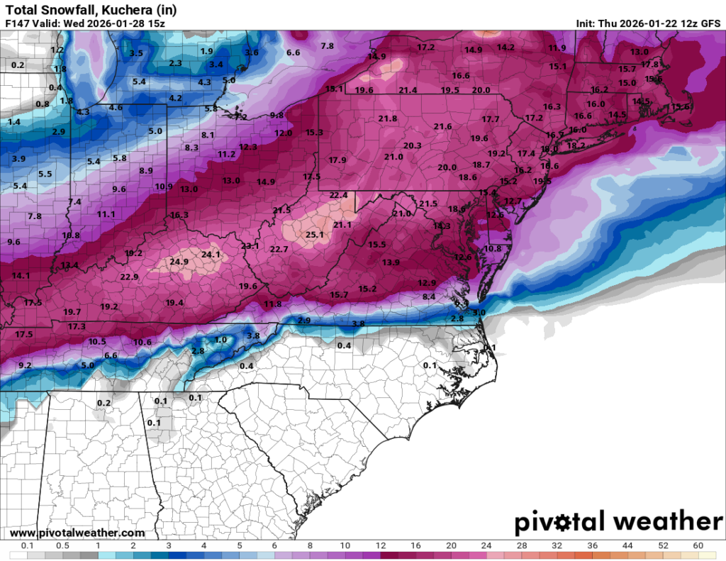
GFS / RRFS hold the mix off longer, which would support higher totals (10–15″).
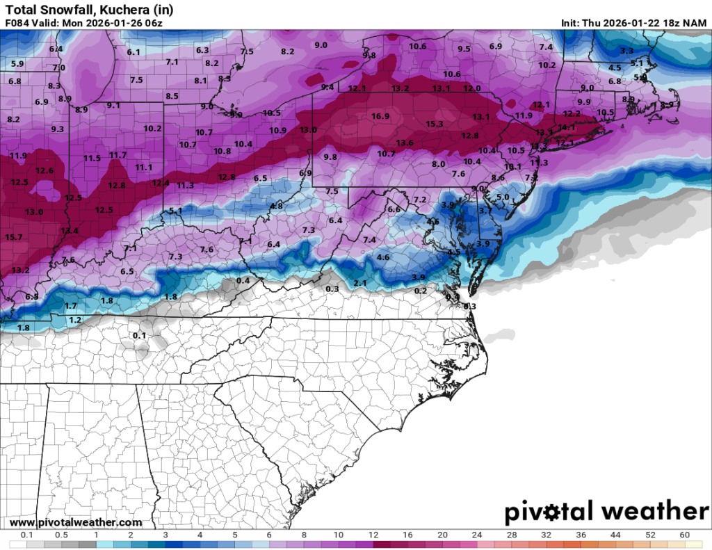
NAM / RDPS / ICON bring mixing in earlier, which knocks totals down into the 5–10″ range.
In terms of timing, snow overspreads the area around sunrise Sunday, continues through the day, and then we watch for a possible change to sleet around 5–7 PM.
Right now I’m leaning toward the changeover happening, and that would cap snow totals. Models also show a pretty meaningful amount of sleet, so at the moment I’m going with 4–8″ of snow area-wide plus a significant sleet layer on top, expect higher totals north and west of the city where mixing is less likely.
One important note: that warm layer is very shallow and barely warm enough to changeover to sleet, only about 1–2° above freezing. So a small shift over the next 24 hours could easily swing us back toward mostly or all snow, and the 10–15″ scenario would come right back into play.
Precipitation should end overnight Sunday night, wrapping up before sunrise Monday (ending southwest to northeast).
Quick update this morning: Most of the overnight models are now showing sleet moving into our area toward the end of the storm. Depending on when that happens it will have an impact on totals. My forecast is now 6 to 12 inches area wide with a question mark regarding the changeover timing. We still need to nail that down. The GFS is currently off on its own showing 10 to 15 inches or more as it does not change over like almost all the others. But winter weather is coming either way.
As of this evening, we are still on track for a significant snowfall to impact the whole region.
The snow looks to begin on Sunday morning, spreading from South to North by sunrise. At the start, temperatures will be VERY cold (teens), which is a key ingredient here. That cold air means we will see good snow growth and high ratios; in other words, this will likely be the fluffy kind of snow that accumulates quickly. The snow is expected to continue right through until early Monday.
One outstanding question with the storm is if and when the snow changes over to sleet. Some models are introducing sleet towards the end of the storm. If that mixing occurs, it will reduce the overall snowfall, likely holding totals to the 7–9 inch range. Other models keep the cold air locked in with snow throughout the entire event. These non-mixing solutions are maxing out as high as 18 inches.
My Forecast Right now, my initial call is for a general 8–14 inches area-wide, with slightly higher amounts likely north of Long Island and the city.
We still need to work out if and when the snow mixes with sleet. That mixing line will have a direct impact on the final totals. But the bottom line remains: we are expecting a significant snowfall on Sunday into Monday morning
While it’s still a long way out in the weather world, the major models are starting to raise eyebrows for Sunday into Monday, showing the potential for a significant snowfall across the entire region.
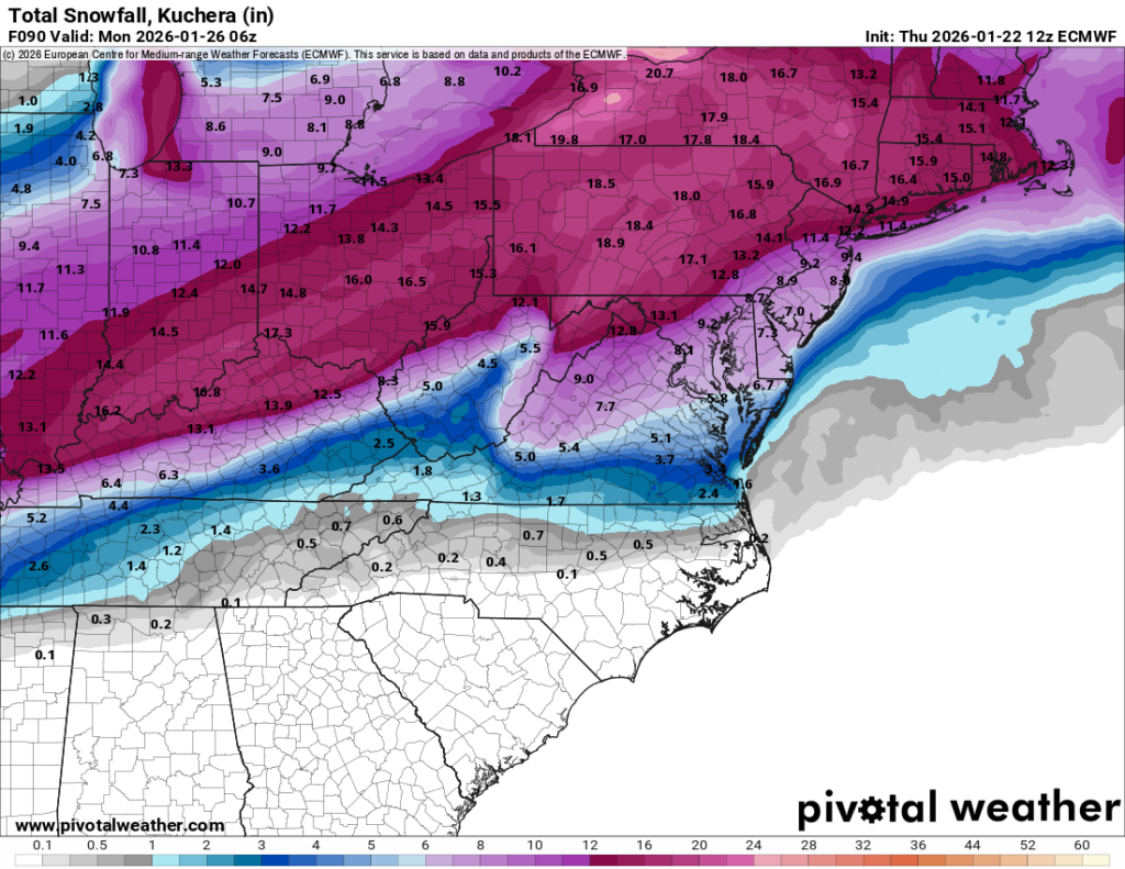
It’s far too early to lock in specifics, but this is definitely a timeframe worth watching closely. The potential setup here gives this storm a very high ceiling. If some of the more aggressive solutions (looking at you, Euro) end up verifying, we could be talking well over a foot of snow by Monday.
As we get closer, I’ll start posting more detailed updates, including model trends and timing.
And yes, I’ve already started acting like my job is to refresh model runs and live and die by every run.