Just a quick update on the storm for tonight into tomorrow: The storm is tracking further North than originally forecast. Therefore, we’re going to see mostly if not all rain. There may be some light snow at the start this evening, but that will quickly change over. Enjoy the soaking!
Sorry for the lack of an update last night, the real world got in the way of storm tracking. Nonetheless, I am here now with an update:
As you can see this morning, we are receiving anywhere from a coating to an inch of snow area-wide. The system that is passing through this morning will help to pull down cold air from Canada for this weekends event. For this weekend, the forecast is still very tricky and all timing based. There is no doubt that we all will see snow to start out, and then most if not all will change to a mix of sleet/ice/rain by Sunday morning. The critical part of this is the timing of the changeover, and depending on what model you’re looking at this changeover varies by a few hours. Additionally, some of the models stay colder throughout the event while others warm more.
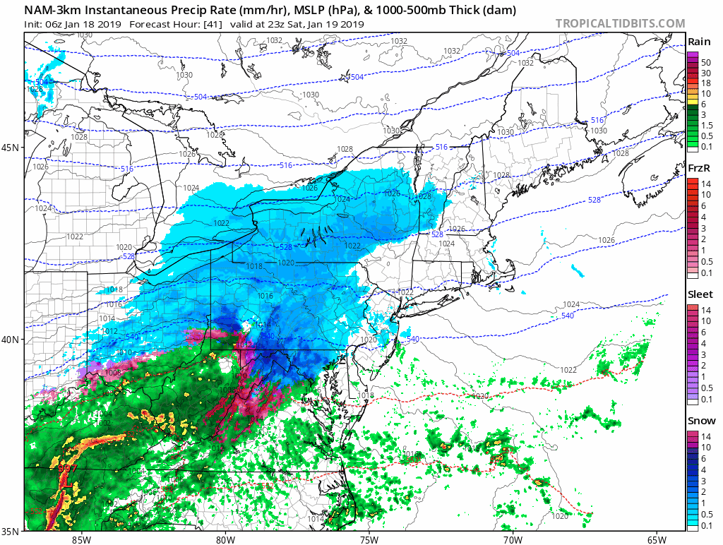
Snow should begin to overspread the area between 7-11 PM on Saturday evening, and continue into the overnight hours. Sometime overnight between 3-6 AM we will see a changeover to the above mixed precipitation. The further east and south you are the earlier you should changeover. This will be a classic now-cast event since the changeover is all dependent on how strong the winds in the middle atmosphere are. The NAM and other Hi-Res models show these winds to be weak, which will keep us colder, while the Euro and GFS warm the mid-levels more, which leads to more of a changeover to rain.
At this point, I am waiting to see what the GEM-LAM, 3K NAM, and HRRR all show tomorrow afternoon before feeling 100% confident in the forecast. However, I am confident to say that conditions will deteriorate rapidly tomorrow evening, with stormy conditions continuing through mid-day on Sunday. Behind the storm will come the coldest weather of the year, so if there is any snow/slush on the ground, I suggest shoveling it up because it will freeze solid by Sunday evening.
As far as totals, they will be hard to nail down exactly as the mixing/rain will cause the snow that falls to melt. However, in general from Suffolk county, West to the Southern part of Nassau you can expect a C-3″. On the northern side of Nassau into Queens and Brooklyn, you can expect 1-4″. Manhattan, you may not see much accumulate at all despite the cold temperatures, possibly a slushy inch or two. The bigger accumulations will begin as you move North of the Bronx.
A quick update on the storm for this weekend: Models continue to vary on the final evolution of the storm for this weekend. I should be able to give a more refined forecast with timings either tomorrow evening or on Friday. This is not an easy forecast, since as I alluded to last night a few hours makes a significant difference in the interaction of the upper air features. This has downstream effects on how the storm will unfold this weekend.
Overall we can all expect snow to begin overnight Saturday and then depending on the track and your location, continue into early Sunday. As of now it appears that all of us will change over to sleet and rain on Sunday at some point. The exact timing of the changeover remains the wildcard as of this evening. The storm will end with a chance for some additional snow, and temperatures will drop rapidly into the single digits…More info to come…
Well the good ole TV Weather Personalities winter weather hype has begun. As many of you have heard, there is a chance for a strong storm to pass through our area starting late Saturday night through Sunday. What this storm actually will look like, I’m not sure yet. All that I do know is that we have several scenarios possible, and that one of them will not make many people happy…
Short version:
Scenario 1: Heavy rain storm all day Sunday, followed by a steep temperature drop Sunday night (GFS, EURO as of this morning)
Scenario 2: Heavy snow to start, changing to heavy rain, followed by a steep temperature drop (EURO until this morning)
Scenario 3: Heavy snow for most of the Sunday, with a change to rain/freezing rain accompanied by the steep temperature drop (UKIE, ICON, and Deep Thunder)
Which scenario do I favor? I don’t want to commit to one since a slight shift at this range makes all the difference, as of now I’m leaning towards a blend of scenarios 1 and 2.
Longer version:
We are finally entering into a true winter pattern which has been missing all winter. You can thank the sudden stratospheric warming event that occurred a few weeks ago for this. The Polar Vortex along with the Pacific are finally in better alignment to bring cold temperatures and winter weather to our area. The first stage of this potential event comes on Friday when an area of low pressure passes through our region. This low pressure will bring either some light rain or snow to the area (I’m favoring snow). What this low does after it passes through our region is critical to what happens next. It’s all a matter of how strong or weak the low is, which will cause trickle down effects throughout the atmosphere across the United States. Once the low passes through, it sets the stage for the storm that will develop over the Southwest early on Saturday. Track one brings the low across the South and exits it off the coast somewhere between Southern New Jersey and the Delmarva, and track up the coast. The other track that it could take would be Northeastward across the country and end up passing somewhere just over or to the West of NYC. The track is critical to the type of precipitation and event that we will experience on Sunday. The critical feature in all this is whether the northern stream/polar vortex phases with the energy moving across the South. The difference in timing is about 6 hours on the models for those that phase the energy and those that don’t. Either way, after the storm passes through the area we will experience the coldest weather of the season with temperatures likely dropping into the single digits overnight Sunday into Monday.
There is a whole lot of time to go with this storm, and a shift in the track of 50-100 miles (Model error can be up to 300 miles at this range) will make a significant difference in the weather that we will experience this weekend.