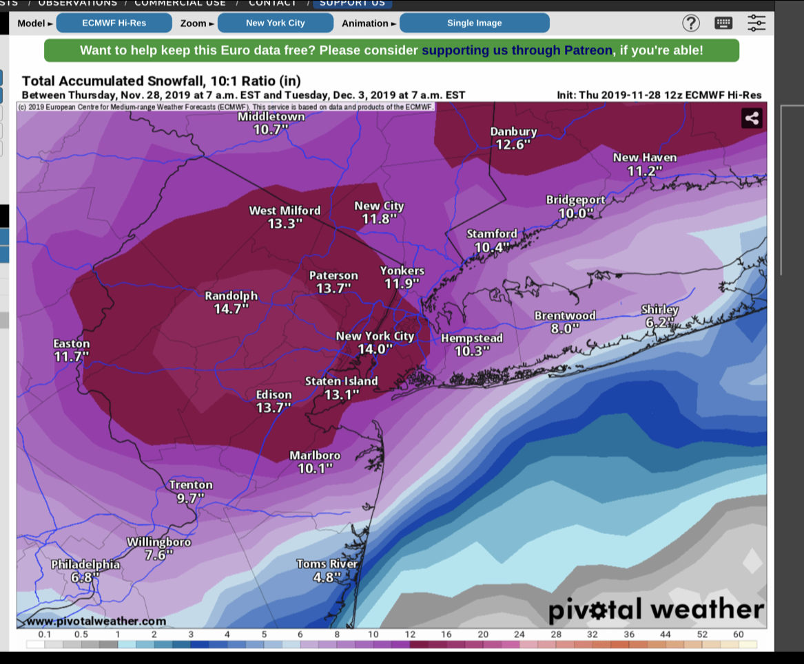
Happy Thanksgiving!!! Unfortunately, I bring some bad news to you today: It looks like we may have our first snowstorm of the year Sunday into Monday. There is still some uncertainty if this will actually happen but the models do seem to be trending towards some snowfall. Take a look at the map below to see the latest Euro forecast… More to come in regards to timing, impacts, and if the storm will actually happen.
A quick rundown on tonights storm follows below. The Goldberg Weather household has been very busy, hence the lack of updates:
The storm should start somewhere between 5&7pm with light possibly mixed precipitation. The storm will continue as snow with some mixing occurring, especially on the South Shore. The snow will end sometime overnight before sunrise. By the end of the storm you can expect 2-4″ on the South shore and 3-6″ on the North Shore. Someone on the North Shore may see closer to 8″ but I’m not confident in that.
Our region is expecting another round of wintry weather overnight tonight. As with the last round, it will be relatively low impact, and will end with some light rain. Precipitation will begin to overspread the area by about 9PM this evening. Areas to the south of the city, will likely see all rain for the duration of the storm. Areas from NYC’s latitude North will begin as snow, and eventually change over by the morning. Southern Connecticut and the Lower Hudson Valley may stay as snow throughout the whole storm, with some possible mixing towards the end of the storm.
This storm will be one where the further North you are the more likely you are to see accumulating snow, this applies to Long Island as well. The South Shore may see no more than a coating while areas North of the LIE may see around 2 inches. As I stated earlier, overall the storm will be low impact to the area, and precipitation will end by early Monday morning.
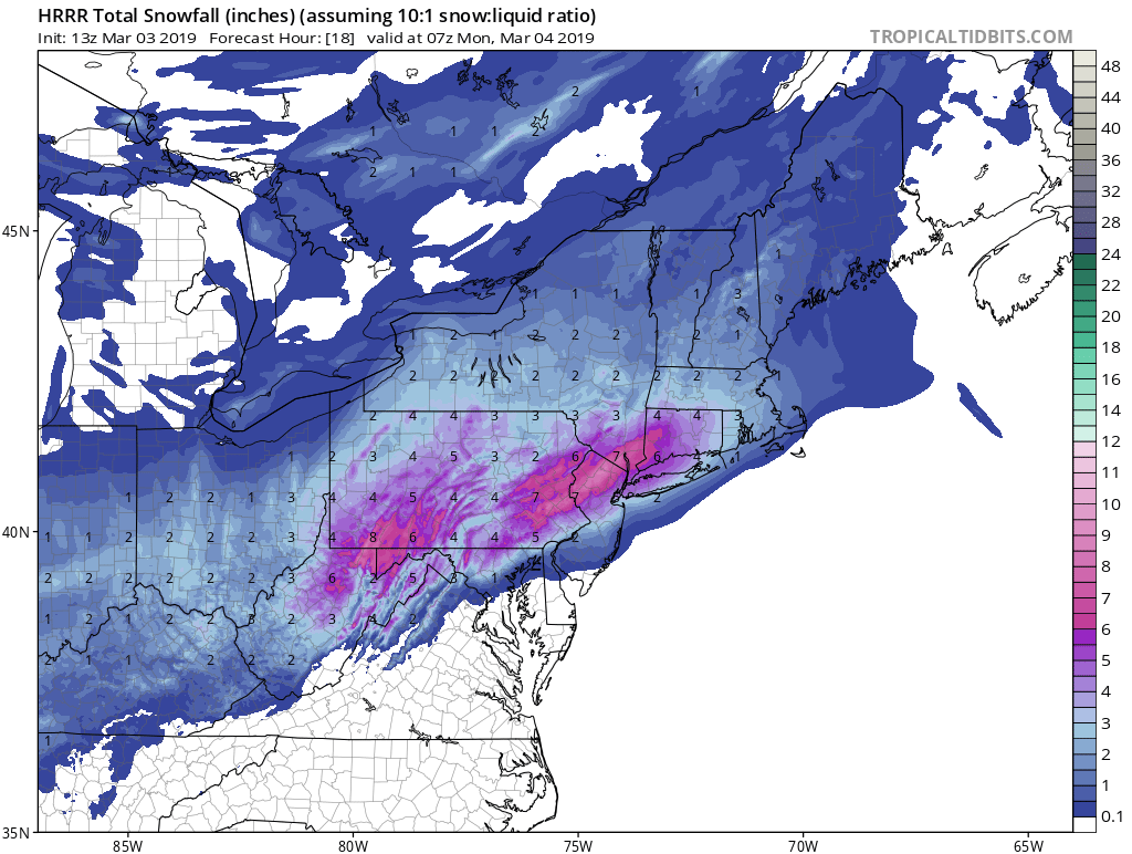
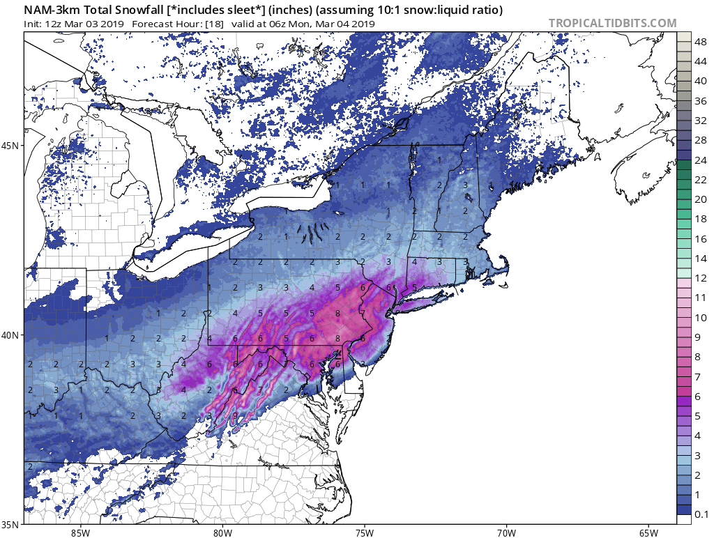
I have not posted much about tomorrows event, simply because I’m not that impressed by it. Overall, we’re looking at a minor winter weather event for the area. Snow will begin tomorrow morning between 7 AM and 9 AM. Snow will continue throughout the morning before changing to sleet sometime around mid-day. Finally in the late afternoon or early evening the sleet will change over to rain. The further East you are the earlier the earlier the changeover to rain, the further North and West, the longer the sleet/snow will hold on.
Snow totals will be somewhere in the neighborhood of a coating to 2 inches, more West and less East. Additionally, we may see half an inch to an inch of sleet accumulation. The sleet accumulation will be highly dependent on surface temperatures and on how cold the lower and mid-levels of the atmosphere can stay.
Just a quick update on the storm for tonight into tomorrow: The storm is tracking further North than originally forecast. Therefore, we’re going to see mostly if not all rain. There may be some light snow at the start this evening, but that will quickly change over. Enjoy the soaking!
Sorry for the lack of an update last night, the real world got in the way of storm tracking. Nonetheless, I am here now with an update:
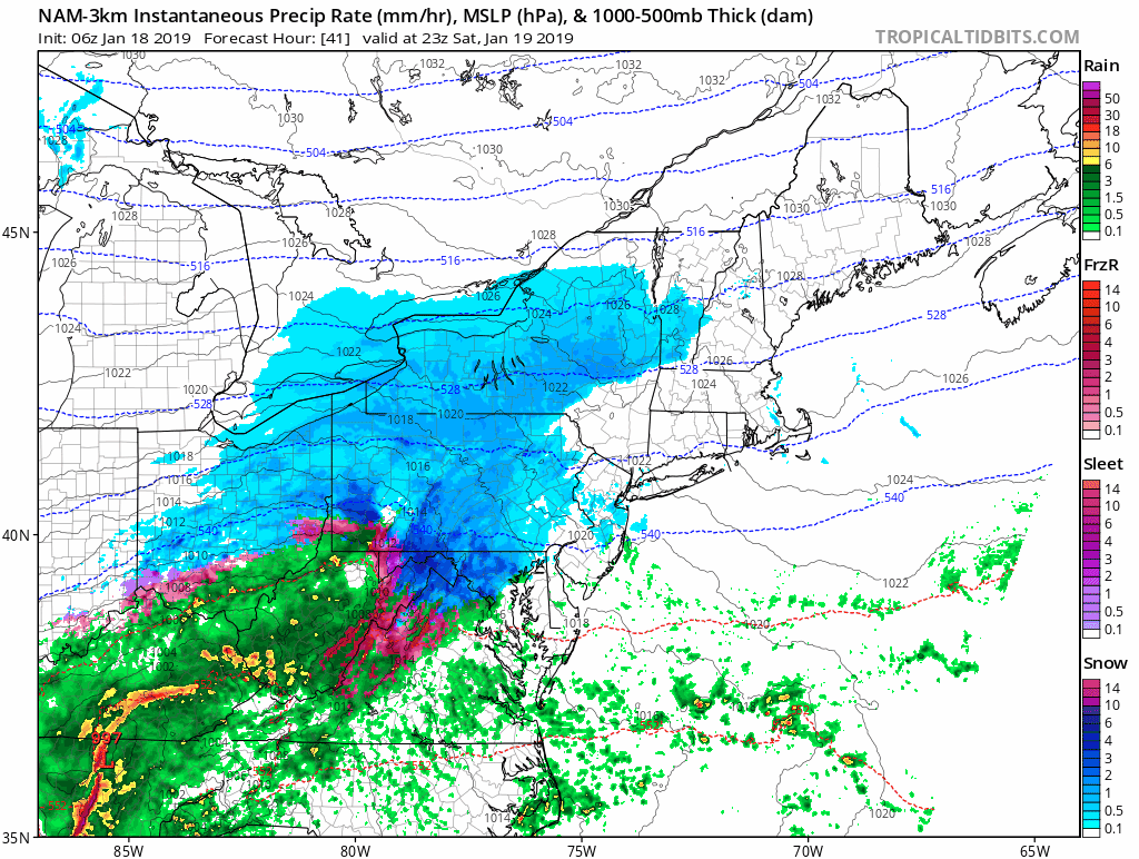
As you can see this morning, we are receiving anywhere from a coating to an inch of snow area-wide. The system that is passing through this morning will help to pull down cold air from Canada for this weekends event. For this weekend, the forecast is still very tricky and all timing based. There is no doubt that we all will see snow to start out, and then most if not all will change to a mix of sleet/ice/rain by Sunday morning. The critical part of this is the timing of the changeover, and depending on what model you’re looking at this changeover varies by a few hours. Additionally, some of the models stay colder throughout the event while others warm more.
Snow should begin to overspread the area between 7-11 PM on Saturday evening, and continue into the overnight hours. Sometime overnight between 3-6 AM we will see a changeover to the above mixed precipitation. The further east and south you are the earlier you should changeover. This will be a classic now-cast event since the changeover is all dependent on how strong the winds in the middle atmosphere are. The NAM and other Hi-Res models show these winds to be weak, which will keep us colder, while the Euro and GFS warm the mid-levels more, which leads to more of a changeover to rain.
At this point, I am waiting to see what the GEM-LAM, 3K NAM, and HRRR all show tomorrow afternoon before feeling 100% confident in the forecast. However, I am confident to say that conditions will deteriorate rapidly tomorrow evening, with stormy conditions continuing through mid-day on Sunday. Behind the storm will come the coldest weather of the year, so if there is any snow/slush on the ground, I suggest shoveling it up because it will freeze solid by Sunday evening.
As far as totals, they will be hard to nail down exactly as the mixing/rain will cause the snow that falls to melt. However, in general from Suffolk county, West to the Southern part of Nassau you can expect a C-3″. On the northern side of Nassau into Queens and Brooklyn, you can expect 1-4″. Manhattan, you may not see much accumulate at all despite the cold temperatures, possibly a slushy inch or two. The bigger accumulations will begin as you move North of the Bronx.


 I have not posted much about tomorrows event, simply because I’m not that impressed by it. Overall, we’re looking at a minor winter weather event for the area. Snow will begin tomorrow morning between 7 AM and 9 AM. Snow will continue throughout the morning before changing to sleet sometime around mid-day. Finally in the late afternoon or early evening the sleet will change over to rain. The further East you are the earlier the earlier the changeover to rain, the further North and West, the longer the sleet/snow will hold on.