Goldberg Weather Live Updated 6:14 PM

All posts

Sunday Night Storm: The Soakers Got Soakier, the GFS Ran Away
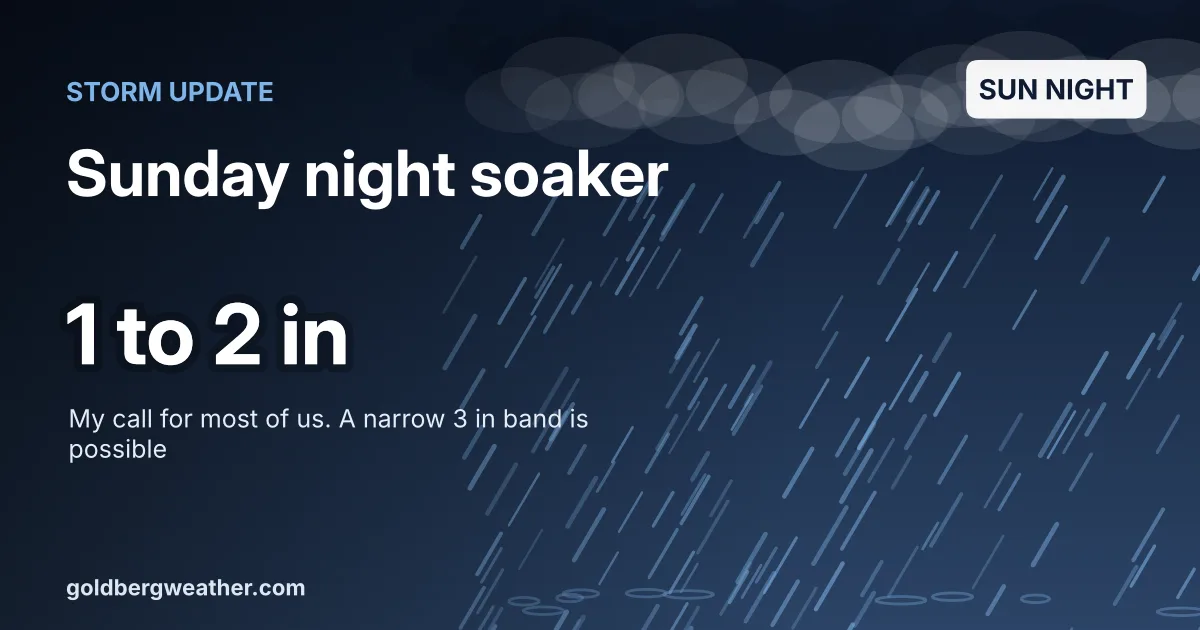
Dark storm cover with heavy rain streaks reading Storm update, Sunday night soaker, 1 to 2 in, my call for most of us with a narrow 3 inch band possible.

Following up on Wednesday's post about Sunday night's coastal storm, this afternoon's runs pushed the heavy end up, not down.

TLDR: A soaking rain arrives Sunday afternoon, peaks Sunday night and tapers Monday morning. Most of us get 1-2", with a narrow stripe near 3" possible over LI or the city, and gusts of 25-40 mph.
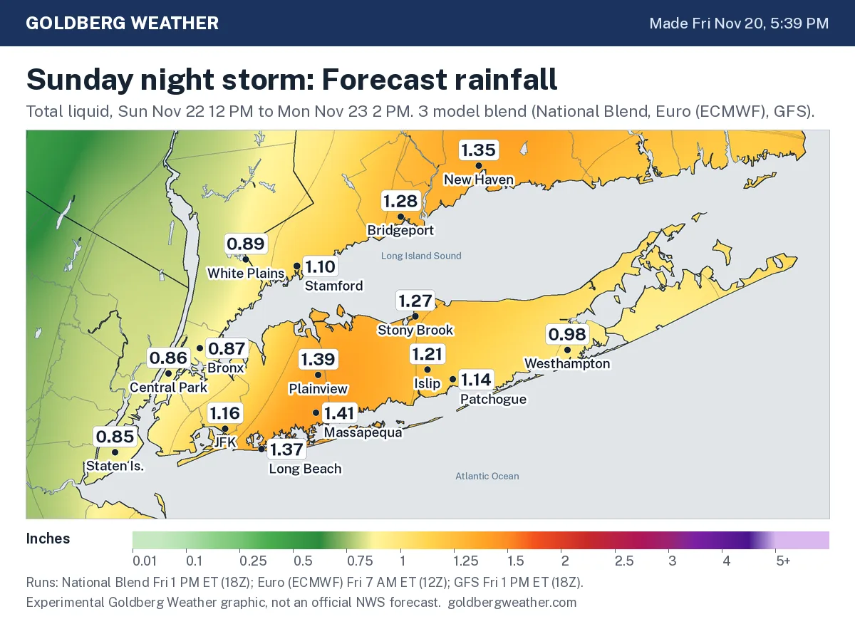
Local rain map for NYC, Long Island and Westchester. Heaviest totals of about 1.4 inches sit over central Nassau and western Suffolk, with Farmingdale 1.4 and Central Park 0.86; lightest amounts are north and west of the city.
Rain totals, Sun 12 PM to Mon 2 PM. Goldberg Weather blend of the National Blend and GFS (Fri 1 PM ET) and Euro (Fri 7 AM ET). Not official.
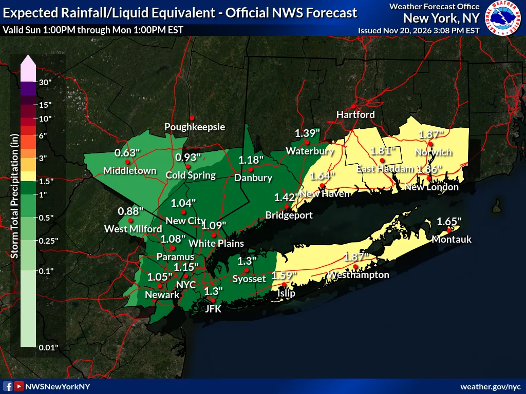
Official NWS Upton expected rainfall map for Sunday 1 PM to Monday 1 PM, showing 1 to 2 inches across Long Island and NYC, about 1.15 inches in NYC and up to 1.87 inches at Westhampton.
Official NWS Upton rainfall forecast, Sun 1 PM to Mon 1 PM, issued Fri Nov 20 3:08 PM ET.
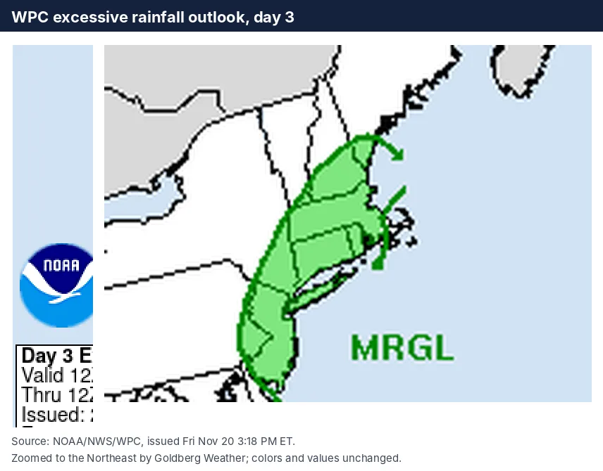
WPC day 3 excessive rainfall outlook zoomed to the Northeast, with a Marginal Risk covering NYC, Long Island and southern New England.
Official WPC excessive rainfall outlook, day 3 (7 AM Sun to 7 AM Mon), issued Fri Nov 20 3:18 PM ET. Marginal Risk over our region.
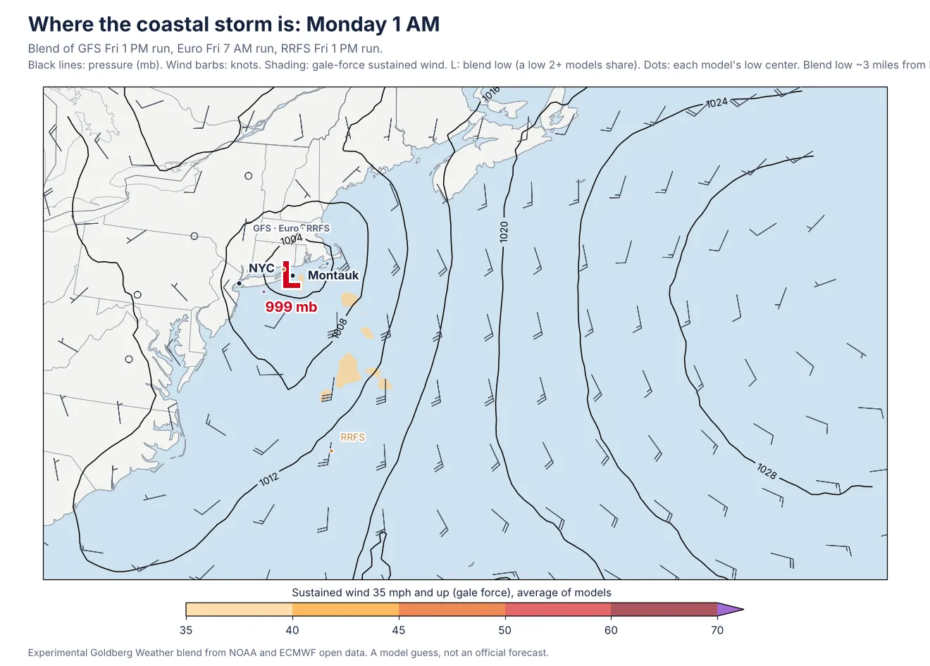
Map of the coastal low at 1 AM Monday. The blended low sits right near Montauk at about 999 mb; the RRFS center is over the east end, the Euro center just off the south shore and the GFS center already out toward the Cape.
The coastal storm at 1 AM Mon, blend of the GFS and RRFS (Fri 1 PM ET) and Euro (Fri 7 AM ET). Lines are pressure, dots are each model's low center. Not official.
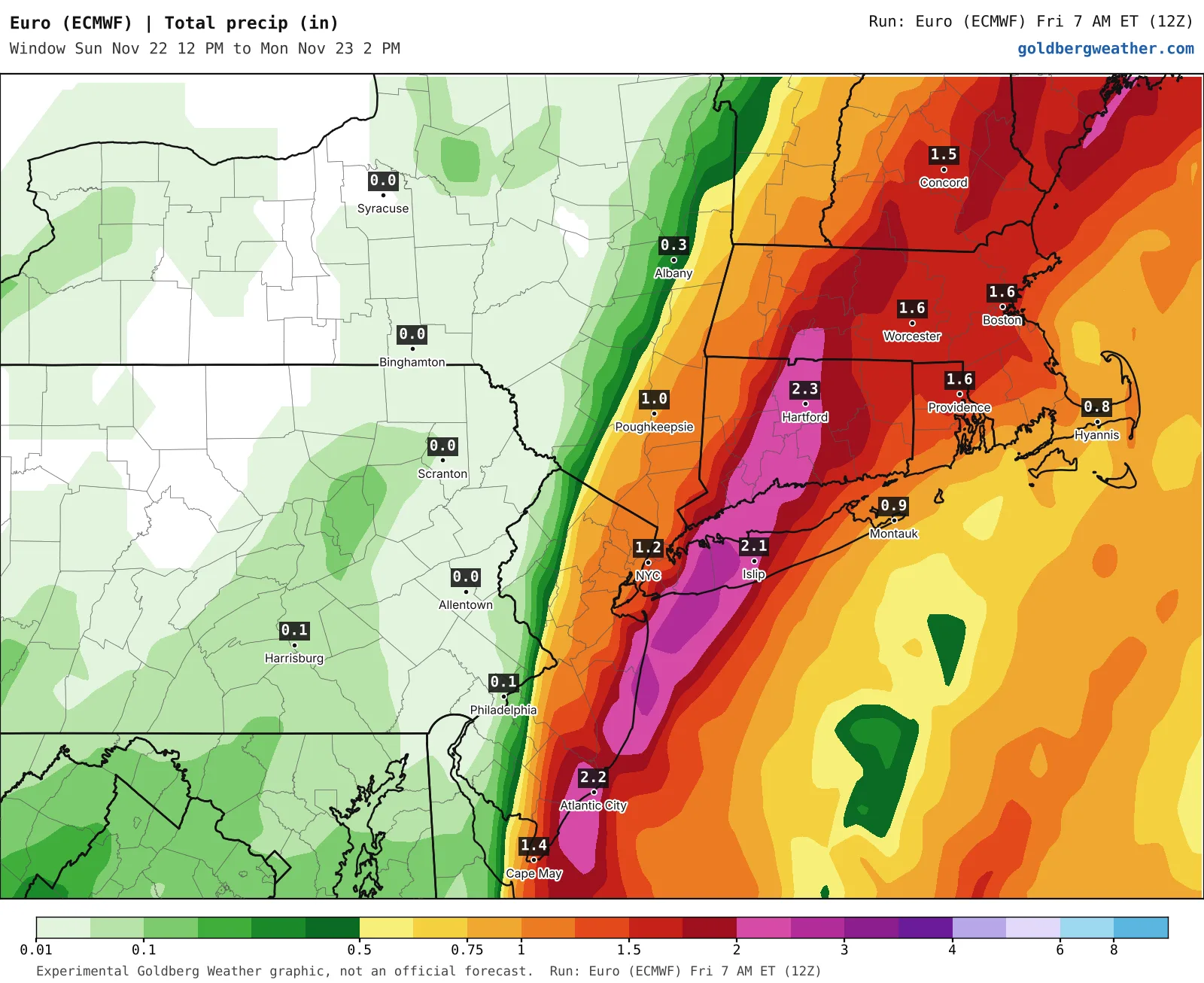
Euro rain map for the Northeast with a stripe of 2 to 3 inches running over western and central Long Island and into Connecticut; NYC about 1.2 inches, Islip about 2.1.
Euro, Fri 7 AM ET run, total rain Sun 12 PM to Mon 2 PM. Raw model output.
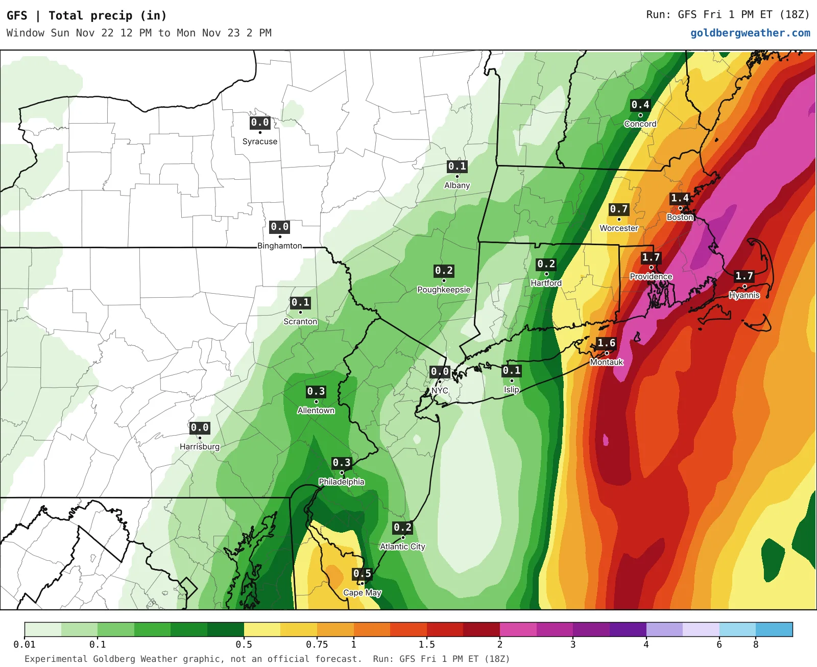
GFS rain map for the Northeast with the heavy rain shifted east over Montauk, Rhode Island and Cape Cod; NYC near zero and Islip about 0.15 inches, Montauk about 1.6.
GFS, Fri 1 PM ET run, total rain Sun 12 PM to Mon 2 PM. Raw model output.
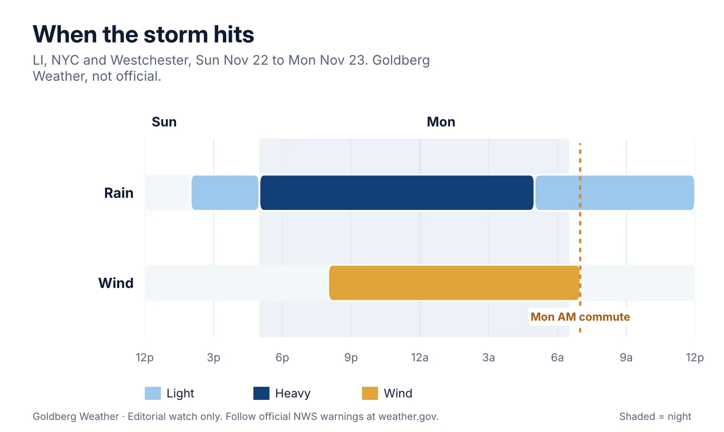
Timeline for LI, NYC and Westchester: light rain Sunday afternoon, heavy rain from dark Sunday through early Monday, light rain tapering Monday morning, wind peaking Sunday night into the Monday morning commute.
Storm timing, Sun afternoon to Mon midday, from the desk record and NWS discussion. Not official.

No watches or warnings yet, but the National Weather Service in Upton is flagging that stripe and a marginal flash flood risk, and WPC has us in a Marginal Risk for excessive rain. Keep an eye on weather.gov/okx.

Rain moves in Sunday afternoon, a bit earlier than yesterday's look, and the worst lands after dark at rates that could top half an inch an hour. Storm drains tend to lose that argument. It clears out Monday afternoon. The east end could gust near 50 mph if the low tracks right over the island, while coastal flooding looks minor since high tide comes after the low passes.

Euro / Canadian / RRFS are the soakers, with the RRFS throwing out a frankly rude 4" in the middle of the island. GFS / National Blend are the light side, and the newest GFS shoves the storm east and leaves the city nearly dry (see the Euro and GFS rain maps). The storm map explains it: at 1 AM Monday the RRFS parks the low over the east end, the Euro keeps it just off the south shore, and the GFS is already scooting toward the Cape.

My call: 1-2" for most of us, with a stripe near 3" somewhere on LI. Our blend runs about a quarter lighter than Upton's map in the city, thanks to the GFS. If the GFS swings back west or a Flood Watch goes up, I'll go higher. If the Euro follows the GFS east, I'll back off.

Clear your storm drain Saturday, never drive through a flooded road, and leave extra time Monday morning.

Bottom line: everyone gets wet, someone gets soaked, and nobody knows who yet.

Editorial watch only. Follow official NWS warnings at weather.gov.

Follow on WhatsApp

All posts

My blend My forecast number: a weighted average of eight weather models, with more weight on the ones that have done best at Farmingdale.

Agreement How close the models are to each other. Close together means more confidence; far apart means the forecast could still change.

Confidence How sure I am about a call, from one dot (could easily change) to three (confident).

Bias-corrected Each model's recent habit, like running 2° too warm, is measured against what Farmingdale recorded and taken out before blending. It starts after two weeks of scored days.

Chance of rain From about 80 versions of the American and European models, each run with small tweaks. 7 in 10 means 7 of every 10 versions bring at least 0.04 in that day.